
SWINGO
SWINGO (Shallow Water table INfiltration alGOrithm) is a Fortran command line program to calculate infiltration for soils bounded by a shallow water table.
Program Description
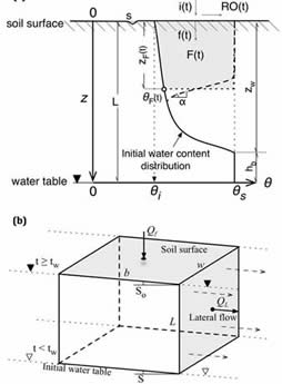
SWINGO simulates infiltration in soils under realistic initially non-ponded conditions with a shallow water table and steady rainfall conditions. The program consists of a time-explicit infiltration solution based on a combination of approaches by Salvucci and Entekhabi (1995) and Chu (1997) with the assumption of a horizontal wetting front. It includes new integral formulae for calculation of the singular times (time of ponding, shift time and time to soil profile saturation). This stand-alone version of SWINGO was developed to study the effects of a shallow water table on infiltration (Muñoz-Carpena et al., 2018). The program is now coupled with VFSMOD to study the effects of a seasonal shallow water table on the effectiveness of vegetative filter strips for water quality mitigation (Lauvernet and Muñoz-Carpena, 2018). Fox et al. (2018) successfully tested the shallow water component of VFSMOD against laboratory experiments.
Program Usage & Output
Unpack the contents of the ZIP package on a directory. The source code (swingo.f and quad.f) and sample files will be written into this directory. You can then compile the fortran file for your system type. For example for Intel Fotran Composer in unix (ifort),
> ifort -o swingo swingo_v1.f quad.f <return>
Part of the program inputs are chosen as arguments from the command line. A short description of the program use can be obtained by executing the program with no arguments:
- > swingo <return>
Name: swingo
(Calculate soil infiltration under shallow water table conditions
using Salvucci/Chu algorithm)
Usage: swingo WTD rain (setim)
Options: WTD: water table depth (m)
rain: rainfall intensity (m/s), if 0 initial ponding
setim: if present, time (s) to print solution
Version: 1.0 for Unix -Jun. 2017
Authors: R.Munoz-Carpena & Claire Lauvernet (UFL & IRSTEA)
The water table depth (m) and rainfall rate (m/s) for each run are read from the command line, where the soil characteristics are provided in the soil input file swingo.iso. (see details in Iinput File Examples section below).. For example, to obtain the cumulative and instantaneous infiltration rate, and wetting front rate time series for a sample clay soil with a shallow water depth (1.5 m) and a rainfall intensity of i=0.73 cm/h (2.4e-6 m/s),
- > swingo 1.5 2.04e-6 <return>
- Water table depth at (m): 1.500
Rainfall intensity (m/s)= 2.040000000000000E-006
Time to ponding, tp(s,h)= 8518.47334380493 2.36624259550137
Shift time, to(s,h)= 4202.11307340253 1.16725363150070
Depth to water table saturation (m)= 0.599990999909999
Time to reach WT, tw(s,h)= 18098.9882335323 5.02749673153676
Cum. infiltration at tw(m,cm)= 3.048812924941849E-002 3.04881292494185
time(h) F(cm) f(cm/h) z(cm)
------------------------------------------------------
0.0251 0.0185 0.7344 0.2040
0.0503 0.0369 0.7344 0.4086
0.0754 0.0554 0.7344 0.6136
0.1005 0.0738 0.7344 0.8191
0.1257 0.0923 0.7344 1.0252
...
Input File Examples
a) Structure of the file
The program input file (swingo.iso) is written in ASCII format and are compatible with VFSMOD, with the following structure:
VKS SAV OS OI SM SCHK
WTD
ITHETATYPE PAR(I)
IKUNSTYPE PARK(J)
ITWBC RVH
b) Parameter definition
VKS saturated hydraulic conductivity, Ks (m/s)
SAV Green-Ampt’s average suction at wet front(m) (needed in file but not used)
OS saturated soil-water content (m3/m3)
OI initial soil-water content (m3/m3)
SM maximum surface storage (m)
SCHK relative distance from de upper filter edge where the check for ponding conditions is made (i.e. 1= end filter, 0.5= mid point, 0= beginning)
WTD water table depth (m)
ITHETATYPE an integer to select the soil water characteristic curve type with values: 1= van Genuchten, 2= Brooks and Corey
PAR(I) parameters of the soil water retention curve for van Genuchten (VG) or Brooks and Corey (BC). The inputs will correspond to different values depending if the characteristic curve selected is van Genuchten (ITHETATYPE=1) or Brooks and Corey (ITHETATYPE=2) (see Muñoz-Carpena et al, 2018, App. A for definitions):
van Genuchten : 1 OR VGALPHA[1/m] VGN VGM
Brooks & Corey: 2 OR BCALPHA[1/m] BCLAMBDA
Note: for Brooks and Corey, BCALPHA = 1/Hb (Hb[m]=bubbling pressure).
IKUNSTYPE an integer to select the unsaturated hydraulic conductivity curve type with values: 1= van Genuchten, 2= Brooks and Corey and 3=Gardner’s
PARK(J) parameters of the unsaturated hydraulic conductivity van Genuchten (VG), Brooks and Corey (BC) and Gardner (GND). The inputs will correspond to different values depending if the characteristic curve selected is van Genuchten (IKUNSTYPE=1), Brooks and Corey (ITKUNSTYPE=2) or Gardner (IKUNSTYPE=3) (see Muñoz-Carpena et al, 2018, App. A for definitions):
van Genuchten : 1 VGM
Brooks & Corey: 2 BCETA BCALPHA[1/m]
Gardner : 3 GDNALPHA[1/m] GNDN
ITWBC, RVH end time boundary condition- 1(or number missing): Dupuis-Forchheimer, lateral drainage to a stream, f=VKS.FWIDTH.WTD/VL.avgSlope; 2: Vachaud vertical saturated flow to a deeper horizon, f=VKS. RVH: VKS/LateralKs so LateralKs=VKS/RVH) (if not present default RVH=1)
c) Example input files (swingo.iso)
van Genuchten characteristics:
3.4e-07 2.63889e-05 0.25542 0.340 0.20889 0 1 --> Ks(m/s) Sav(m) Theta-s Theta-i Sm(m) Schk
0.925 --> Water table depth (m)
1 0.06356 3.024 2.8759 0.65228 --> ITHETATYPE OR VGALPHA VGN VGM
1 0.65228 --> IKUNSATYPE VGM
2 --> Vachaud vertical boundary condition
Brooks and Corey characteristics:
3.4e-007 1.1694 0.45 .05 0 1 --> Ks(m/s) Sav(m) Theta-s Theta-i Sm(m) Schk
1.5 --> Water table depth (m)
2 0 1.1111 0.44 --> ITHETATYPE OR/OR VGALPHA/BCALPHA VGN/BCLAMBDA VGM
2 7.5455 1.1111 --> IKUNSATYPE VGM/BCETA/GDNALPHA BCALPHA
2 --> Vachaud vertical boundary condition
Brooks and Corey soil water and Gardner hydraulic conductivity characteristics:
3.4e-007 1.1694 0.45 .05 0 1 --> Ks(m/s) Sav(m) Theta-s Theta-i Sm(m) Schk
1.5 --> Water table depth (m)
2 0 1.1111 0.44 --> ITHETATYPE OR/OR VGALPHA/BCALPHA VGN/BCLAMBDA VGM
2 0.136 2.151 --> IKUNSATYPE GDNALPHA GNDN
2 --> Vachaud vertical boundary condition
Ouput Files
The program outputs resutls directly to the screen. If desired they can be written to a file by writing,
- > swingo 1.5 2.04e-6 > clay.out <return>
References
-
Salvucci GD, Entekhabi D.: Ponded infiltration into soils bounded by a water table. Water Resour. Res., 31, 2751-2759, doi:10.1029/95WR01954, 1995.
-
Chu ST.: Infiltration model for soil profiles with a water table. Trans. ASAE., 40(4), 1041-1046, 1997.
-
Muñoz-Carpena, R., Lauvernet, C., and Carluer, N. 2018. Shallow water table effects on water, sediment and pesticide transport in vegetative filter strips: Part A. non-uniform infiltration and soil water redistribution, Hydrol. Earth Syst. Sci. 22:53-70. doi:10.5194/hess-22-53-2018
-
Lauvernet, C. and Muñoz-Carpena, R.. 2018. Shallow water table effects on water, sediment and pesticide transport in vegetative filter strips: Part B. model coupling, application, factor importance and uncertainty, Hydrol. Earth Syst. Sci. 22:71-87. doi:10.5194/hess-22-71-2018
-
Fox, G., R. Muñoz-Carpena and R. Purvis. 2018. Controlled laboratory experiments and modeling of vegetative filter strips with shallow water tables. J. of Hydrology 556(1):1–9, doi:10.1016/j.jhydrol.2017.10.069
Program License
The program was developed for research and teaching purposes. This program is distributed as is with no warranty. If the program is found useful the authors ask that acknowledgment is given to its use in any resulting publication and the authors notified. The source code is available from the authors at the link above.
The model and associated documentation is supplied as-is with no warranty - explicit or implied. The model is provided to you as an educational and research tool under the terms of the Open Source Initiative, Educational Community License, Version 2.0 http://opensource.org/licenses/ecl2.txt).
- Rafael Muñoz-Carpena
Professor, Hydrology & Water Quality
Department of Agricultural
& Biological Engineering
University of Florida
P.O. Box 110570
287 Frazier Rogers Hall
Gainesville, FL 32611-0570
(352) 392-1864 x287
(352) 392-4092 (fax)
carpena@ufl.edu
© Copyright Rafael Muñoz-Carpena
This page was last updated on June 23, 2021.