UF Institute of Food and Agricultural Sciences logo
Give      University of Florida
Resources
    Toggle Search Form
    GIVE UNIVERSITY OF FLORIDA
    • HOME
    • Our Team
            • People
            • Research Team
            • Stakeholders
    • Stakeholders


    • Resources
            • Maps
            • Reports
            • Twifo-Hemang Lower Denkyira District Flyer
            • Asante Akim Central Municipal District Flyer
            • Subheading 1
            • Link 1
            • Link 2
            • Link3
            • Link 4
            • Subheading 2
            • Link 5
            • Link 6
            • Link 7
            • Link 8
            • Subheading 3
            • Link 9
            • Link 10
            • Link 11
            • Link 12
            • Subheading 4
            • Link 13
            • Link 14
            • Link 15
            • Link 16
            • Subheading 5
            • Link 17
            • Link 18
            • Link 19
            • Link 20

    Ghana Land Use Program

    Ghana Land Use Program

    A ariel view of Ghana's capital city, Accra.
    Crowds, market place
    Forest, excavators
    Palm trees, forest, Ghana

    Linking deforestation, urbanization, and agricultural expansion for land-use decisions in Ghana

    Deforestation has significantly impacted West Africa for several decades and Ghana is still experiencing pressures from an increasing population in urban areas. The challenge of identifying land cover change drivers due to the complex interactions among human and natural systems hinders effective land use planning.

    Researchers at the University of Florida (UF) are working with a team of collaborators from the Centre for Remote Sensing and Geographic Information Services (CERSGIS) in Ghana, and the University of Ghana to link deforestation, urbanization, and agricultural expansion for land-use decisions in Ghana.


    GALUP: Ghana Land Use Project

    About The Project

    This project has been awarded by SERVIR, a joint venture between NASA and the U.S. Agency for International Development to help developing countries use Earth-observing satellites and geospatial technologies for managing climate risks and land use.

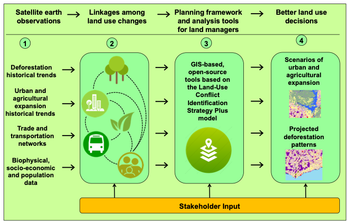
    This project will enhance the current operational planning framework and building capacity for effective land use planning in Ghana. By integrating trends in deforestation, urbanization, and agricultural expansion from remote sensing with GIS-based modeling, this project will identify potential overlaps/conflicts among various sectors and predict land-use change scenarios.

    Jasmeet Judge, principal investigator and a professor in the UF/IFAS Agricultural and Biological Engineering (ABE) department, leads this project with an interdisciplinary team comprising ABE assistant professor Aditya Singh, UF Geography assistant professor Olivier Walther, UF graduate assistant Changjie Chen, CERSGIS executive director Foster Mensah, ABE professor Gregory Kiker, ABE associate professor Rachata Muneepeerakul, and University of Ghana associate professor Kwadwo Owusu.

    Capacity Building

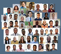
    One of GALUP’s objectives is to help build local capacity in applying tools empowered by Remote Sensing (RS) and Geographic Information System (GIS) technologies to inform and ensure sustainable land use practices.

    Our project includes workshops aiming at helping trainees to familiarize themselves with the use of LUCIS-OPEN, a GIS-based, open-source land use planning framework.

    Read more about GALUP Capacity Building,Workshops participants, 2021


    2023-2025: New Grant to study Land Degradation

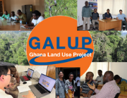
    GALUP was awarded a new grant by NASA to detect and monitor risks of artisanal mining and charcoal production in Ghana.

    Entitled "Integrating Socio-Economic and Remotely Sensed Information to Characterize Conflict Precursors and Land Degradation Dynamics in Ghana", this project will be using remote sensing to develop a land use conflict identification and land degradation framework.

    Read more about this 2nd phase of GALUP


    University of Florida Logo
    Contact

    Feedback
    SERVIR
    P.O. Box 11018 Gainesville, FL 32611-0180
    (352) 392-1971

    Land Grant Mission
    • Teaching
    • Research
    • Extension
    Information
    • Ask IFAS (EDIS)
    • UF/IFAS Experts
    • UF/IFAS Blogs
    • UF/IFAS Bookstore
    Policy
    • Accessible UF
    • EEO Statement
    • IFAS Web Policy
    • SSN & UF Privacy
    • Analytics (Google Privacy)

    © 2025 University of Florida, IFAS Last Modified:Thu, 1 Feb 2024 17:02:44 EST