
Other Water and Environmental Research
A Water Budget Model for Septic Disposal Field Design
Objective
The purpose of the model is to track the height of the water table in each field to assess the probability of failure due to the water table reaching the level of the septic disposal distribution pipes in the septic field or above 0.2 m below the ground surface in the upslope and downslope fields. [more...]
Model Download
- Model (xls)
- Model Guide (doc)
Selected Publications
- Collick, A. C., M. E. Zachary, F. A. Montalto, B. Gao, Y. J. Kim, L. Day, and T. S. Steenhuis. 2006. Hydrological evaluation of septic disposal field performance in sloping terrains. J. of Environmental Engineering 132:1289–1297.
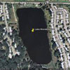
Monitoring Water Quality in Lake Wonderwood
 Summary
Lake Wonderwood is a manmade, freshwater/brackish lake, located on the US Naval Station at Mayport, Florida (NSM). The lake was created to provide fill for the adjacent housing area and has surface area of approximately 20 acres (8.1 hectares) (Appendix 1). The maximum depth of the water is reported to be at least 20 feet (6.1 meters). The lake serves as fish and wildlife habitat, storm water storage and treatment, and as a recreational site. The water from Lake Wonderwood is also used for golf course irrigation when it is not too brackish. As a recreational site for NSM personnel, Lake Wonderwood is well maintained, but water quality issues have been raised recently, particularly with respect to fish kills and the use of the water for irrigation of turfgrass. We are conducting an investigation to monitor the critical limnological, water chemistry, and biological parameters at the Lake. The successful completion of this project will provide natural resource managers with the tools to make scientifically sound determinations as to the most appropriate conservation and improvements to be used for the lake.
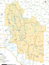
Statistical Evaluation of Hydrologic Data in NE Florida and Southern Georgia
 Summary
This study mainly focus on evaluating the hydrologic data within the upper Suwannee River and Santa Fe River basins. Much of the study area is very karstic, with little sediment cover overlying the Upper Floridan Aquifer (UFA). To the north and east, historic large-scale groundwater withdrawals in northeastern Florida and southeastern Georgia have lowered the potentiometric surface of the Upper Floridan Aquifer (UFA) more than 10 ft over a very large area (USGS). Therefore, there is a need to qualify the effects of pumping into the Suwannee and Santa Fe river basins on groundwater levels. There have been no studies conducted that have comprehensively examined rainfall, groundwater level, and spring/stream discharge time series data in comparison with historical groundwater withdrawals either within the study area.
This project involves: 1) compilation and evaluation of available time series data (rainfall, groundwater levels, stream flow and spring discharge) and ground water withdrawal records; 2) statistical trend analysis of time series; and 3) evaluate the time series correlation.